About this page
How this part of the Local Plan Options Document works
These site allocation pages contain the following sections:
Site background
- A broad description of the site, with map if appropriate
- An overview of development proposed or already in progress
- Relevant aspects of planning policy for this site
- The history and status of any planning applications for this site
Options for the new Local Plan
We may suggest one or more possible approaches:
- Keeping existing plans for this site as they are
- Making small changes to our approach, which may allow for changes
- Replacing the approach with something that is substantially different
- Identifying factors or events which may affect this policy in the future
Site analysis
A short summary of our assessment of the site so far
- Opportunities presented by the site
- Constraints (obstacles which might make it a poor site to develop
- Mitigations (Measures that would be needed to reduce any harm development would cause)
- Further information we'd need to make a more in-depth assessment of the suitability of the site
Policy context note
- Where decisions about this site may affect how we approach other sites (or vice versa), we will add a note to explain
Explore this site allocation
Select a section below to read more.
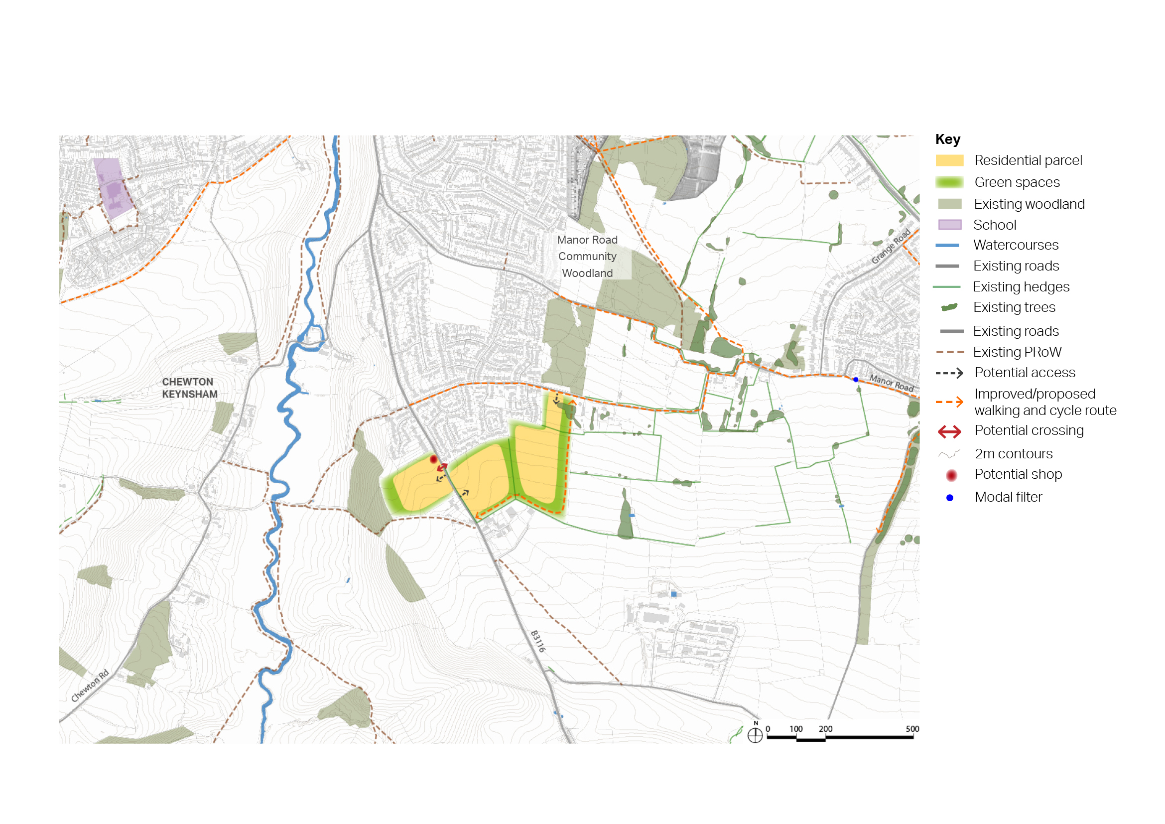
6.56 South East Keynsham is located to the south of the east side of Keynsham, comprising two parcels of land located to the east and west of Wellsway (the B3116). Wellsway connects the town to the A39 to the south.
6.57 The parcel located to the west of Wellsway is used as arable land and is bounded by residential homes to the south and north, and woodland to the west.
6.58 The parcel located to the east of Wellsway is also used as arable land, and extends up to Courtenay Road to the north, to provide a walking and cycling route up into Keynsham, as no permeability exists between the land parcel and the residential development adjoining it to the north.
6.59 A bus stop providing a twice hourly bus service into Bristol to the north, and the Somer Valley to the south, is located on Wellsway close to the site. However, improvements to walking infrastructure to reach the bus stops from the site would be required as limited pavement currently exist.
6.60 The nearest existing convenience shop is located on Chandag Road, approximately 1 mile away from the site.
6.61 The site is located in the Green Belt. The Strategic Green Belt Assessment carried out by WECA to inform the now halted Spatial Development Strategy assesses these land parcels (P84 west of Wellsway, and P85 east of Wellsway) as having the following contributions to each of the NPPF Green Belt purposes:
- Purpose 1 - checking the unrestricted sprawl of large built-up areas: P84 and P85 Limited / no contribution
- Purpose 2 - preventing the merger of neighbouring towns: P84 limited / no contribution, P85 significant contribution
- Purpose 3 – safeguarding the countryside from encroachment: P84 and P85 significant contribution
- Purpose 4 - preserving the setting and special character of historic towns: P84 moderate contribution, P85 limited / no contribution
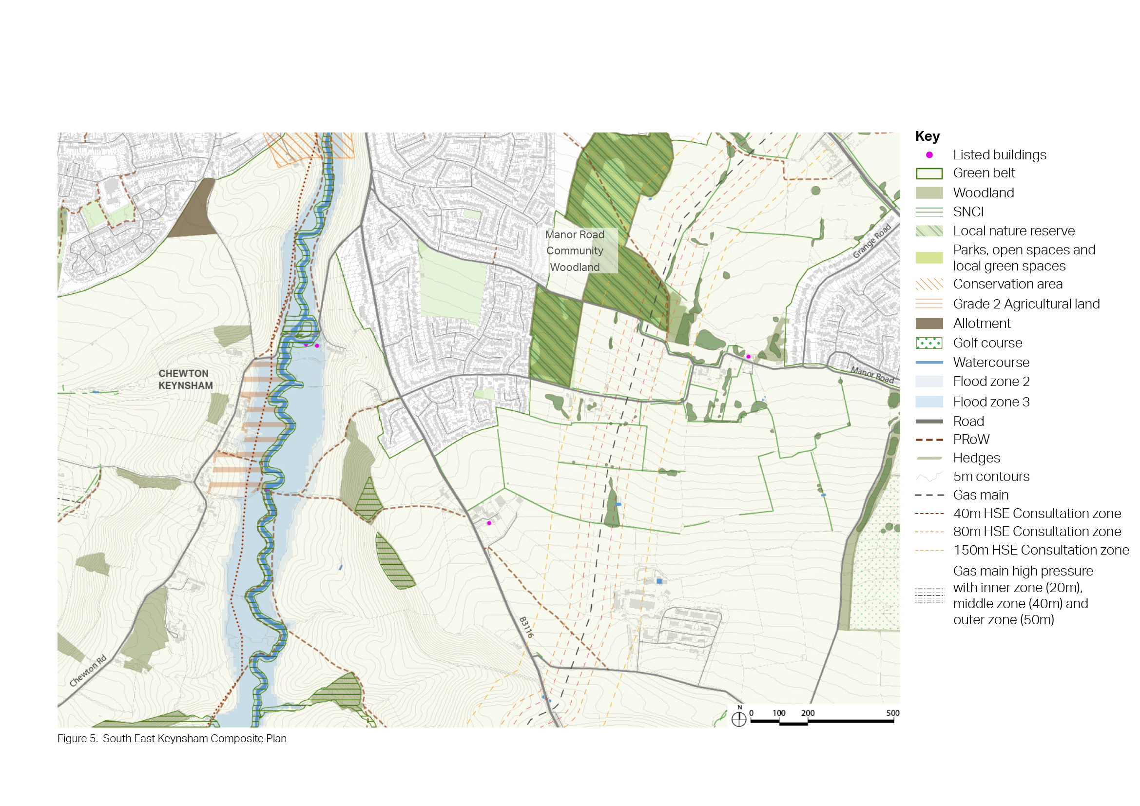
Figure 27 Context plan - South East Keynsham
Opportunities
- Provision of around 350 homes.
- Potential to provide a convenience shop on Wellsway, to serve existing and new residents.
- Opportunities to link development into Manor Road Community Woodland Improvement Project work, including potential for expansion of the existing woodland to the east of the development parcel (noting potential constraint of gas pipeline in this location).
- Opportunity for provision of local food growing.
Constraints
- Located in the Green Belt.
- Poor active travel route availability into Keynsham town centre.
- Significant walking times to nearest convenience shop on Chandag Road, and to Wellsway Primary School.
- No permeability between the site and the existing housing to the north, with potential impact being the creation of an isolated development, severed from the existing town.
- Gas pipeline between Keynsham and Saltford may restrict the types of Green Infrastructure that could be provided between the two settlements.
Mitigation required
- Significant improvements to walking and cycling infrastructure required, both into Keynsham and across to Saltford.
- Significant tree buffer required along eastern boundary of the site, to reduce impact of built development in views from the Cotswold National Landscape.
- Significant street tree planting required throughout development parcels, to reduce impact of development in views from the Cotswold National Landscape.
Further investigation or evidence
- Green Belt assessment required to assess impact of removing land from Green Belt, including cumulative impact when considering strategic removal across the district and considering opportunities for enhancements to retained Green Belt land.
- Exploration of extent of possible green infrastructure enhancements between Keynsham and Saltford required (noting constraint of gas pipeline in this location).


