About this page
How this part of the Local Plan Options Document works
These site allocation pages contain the following sections:
Site background
- A broad description of the site, with map if appropriate
- An overview of development proposed or already in progress
- Relevant aspects of planning policy for this site
- The history and status of any planning applications for this site
Options for the new Local Plan
We may suggest one or more possible approaches:
- Keeping existing plans for this site as they are
- Making small changes to our approach, which may allow for changes
- Replacing the approach with something that is substantially different
- Identifying factors or events which may affect this policy in the future
Site analysis
A short summary of our assessment of the site so far
- Opportunities presented by the site
- Constraints (obstacles which might make it a poor site to develop
- Mitigations (Measures that would be needed to reduce any harm development would cause)
- Further information we'd need to make a more in-depth assessment of the suitability of the site
Policy context note
- Where decisions about this site may affect how we approach other sites (or vice versa), we will add a note to explain
Explore this site allocation
Select a section below to read more.
6.34 North Keynsham is located to the east of Keynsham town centre, and south of the River Avon, separated from the town by the railway line running between Bristol and Bath. Narrow access points via various bridges and tunnels connect the site to Keynsham.
6.35 The site is located in close proximity to the A4, the Bristol and Bath Cycle Path and Keynsham Train Station, all of which provide direct access to Bath and Bristol by bus, train and bicycle.
6.36 Some constraints exist across the site due to its location, existing land uses, and poor connections to its surroundings (see constraints in table below). However, through careful masterplanning and provision of mitigation where required, the site is considered to be a good option for development due to its highly sustainable location.
6.37 Due to its highly sustainable location, if this area is allocated for development in the Local Plan, its deliverable capacity should be optimised. With this in mind, further evidence base work is being undertaken to determine whether a higher quantum of development than set out below could be provided through mitigation of on-site constraints imposed by the water recycling plant and gas pipeline.
6.38 Additional landscape evidence work is also being undertaken to assess the impact of development on the Cotswold National Landscape and its setting.
6.39 The option for potential development at West Saltford will need to be considered in conjunction with this North Keynsham option, with regards to maintaining a significant green gap between Keynsham and Salford, which is a key priority for both settlements.
6.40 A road will be required to access the development site and it is envisaged that it will also play a more strategic role as a relief route, pulling traffic out of Keynsham town centre, to the wider benefit of the town and enabling a greater focus on sustainable modes of transport on the town centre area network.
6.41 The site requires provision of significant infrastructure, not only from a transport perspective, but also to provide services and facilities for future residents. Optimising residential development at the site is considered to be important to both financially support provision of this infrastructure, and secure its long term use.
6.42 The site is located in the Green Belt. The Strategic Green Belt Assessment carried out by WECA to inform the now halted Spatial Development Strategy assesses this land parcel (P72) as having the following contribution to each of the NPPF Green Belt purposes:
- Purpose 1 - Checking the unrestricted sprawl of large built-up areas: Limited / no contribution
- Purpose 2 - Preventing the merger of neighbouring towns: Significant contribution
- Purpose 3 – Safeguarding the countryside from encroachment: Significant contribution
- Purpose 4 - Preserving the setting and special character of historic towns: Moderate contribution
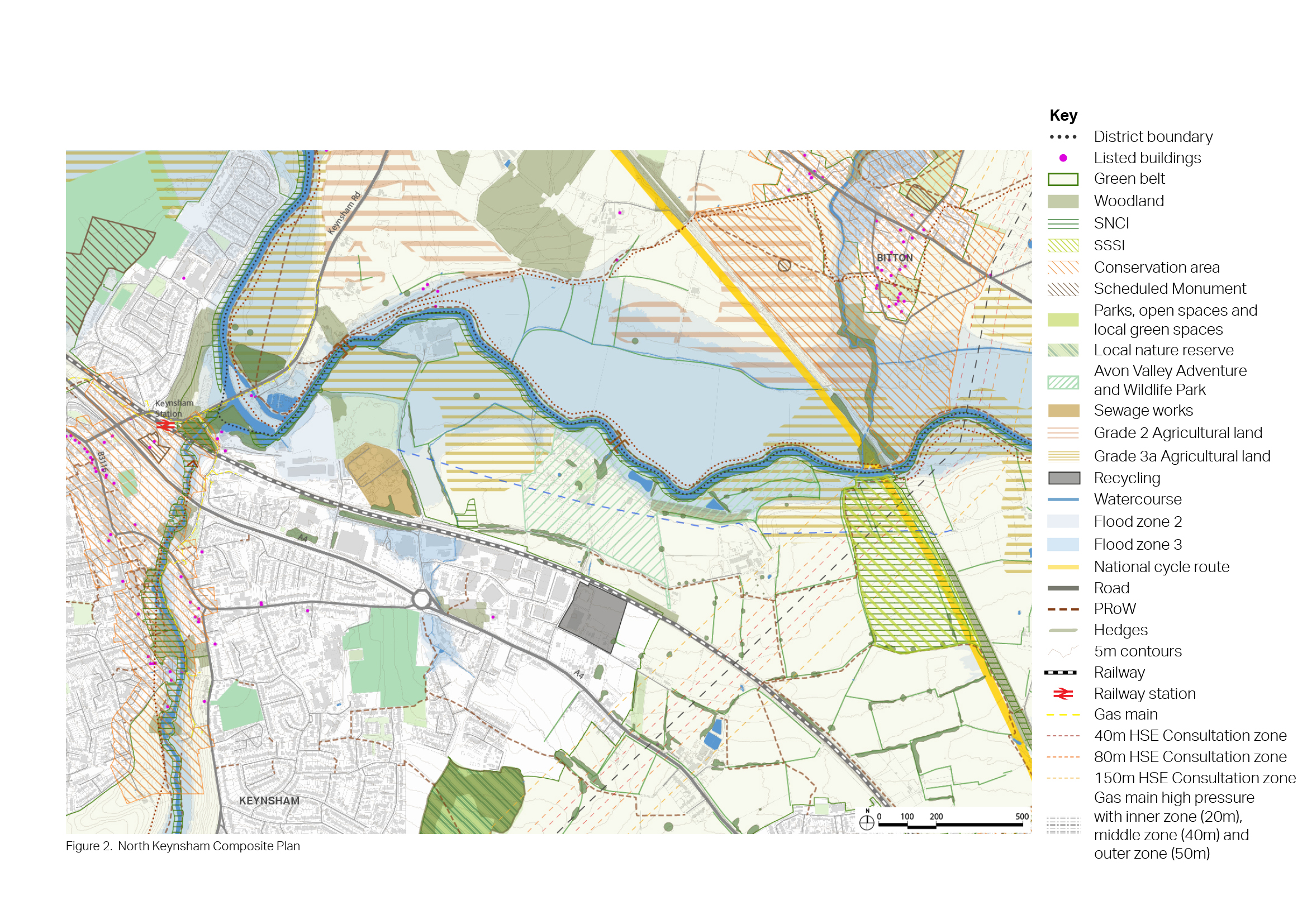
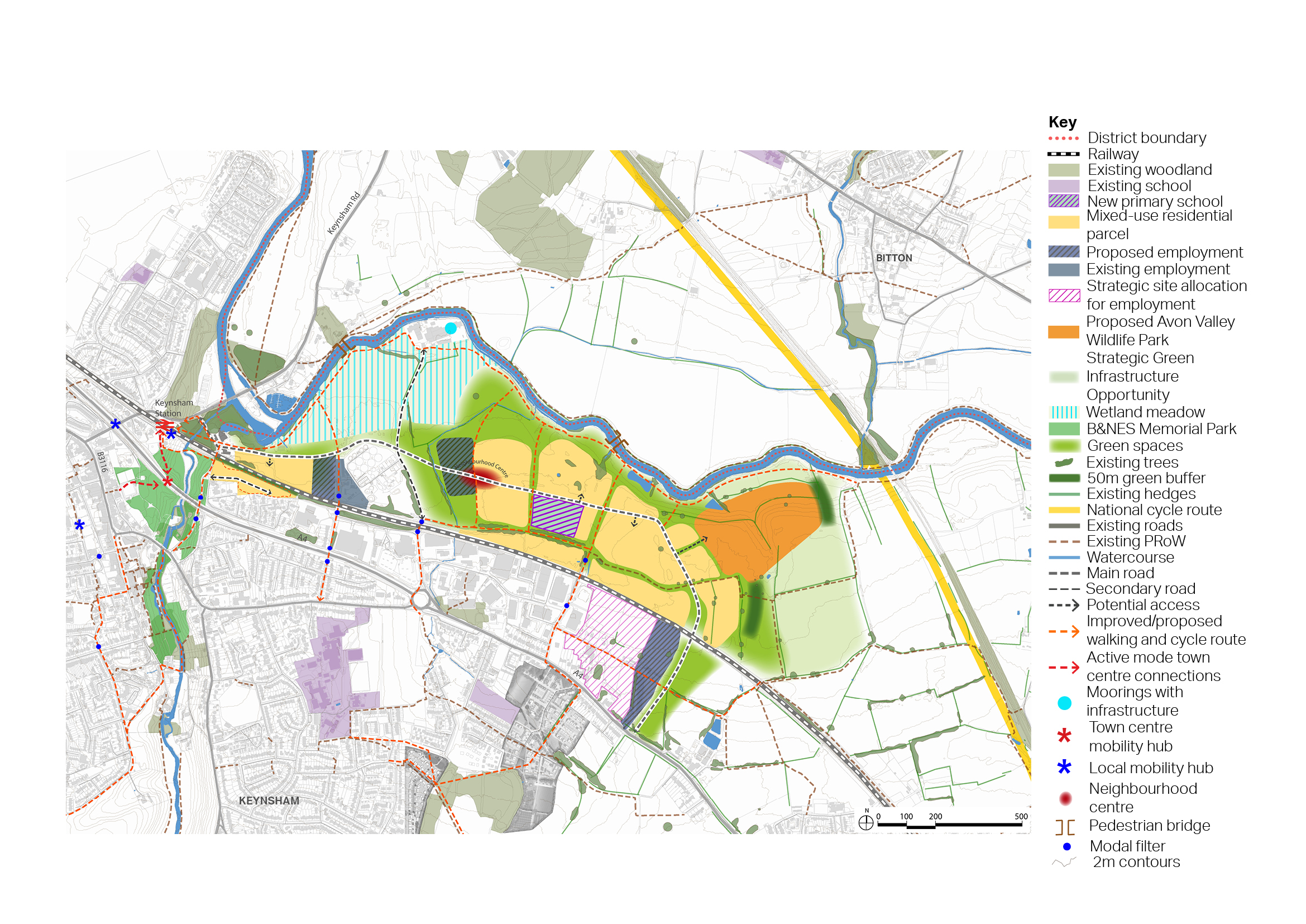
Figure 17: Context Plan - North Keynsham
Opportunities
- Provision of a sustainably located mixed-use development, comprising:
- Around 1,500 new homes, with potential to include an element of Purpose Built Student Accommodation within the wider mix of housing.
- Around 6.5 ha of employment uses.
- A range of community and leisure facilities at the centre of the development, including a primary school, retail provision, community facilities, and the opportunity to provide a cultural facility, such as a hall with theatre, for use by local communities. Located in close proximity to the A4, the Bristol and Bath Cycle Path and Keynsham Train Station, providing direct access to Bath and Bristol by public transport and active travel modes. Potential to provide high quality active travel routes into town centre and also to Bristol to Bath cycle route. Opportunity to provide car free development due to sustainable location.
- Potential to provide a strategic link on the highway network using the access road required by the site to remove traffic from Keynsham town centre, to the wider benefit of the town.
- Potential to explore the use of the river front for moorings and other water-related uses.
- Significant opportunities for nature recovery and wetland habitat within areas located in flood zone 3.
- Potential to explore the creation of woodland habitats linking Keynsham community woodland to the River Avon.
Constraints
- Located in the Green Belt.
- Potential for loss of green gap between Keynsham and Saltford, particularly when considered in addition to option at West Saltford.
- Significant landscape sensitivity considerations relating to the impact of development on the Cotswold National Landscape. The relocation of Avon Valley Wildlife Park to the east will also need to be considered in relation to potential landscape impact on the Cotswolds National Landscape and its setting.
- Stidham Farm SSSI and SNCI located to the east of the site. Broadmead Field SNCI and River Avon SNCI located within the site boundary.
- Access is currently restricted due to the site’s location between the railway line and the River Avon. Narrow access points exist via bridges and tunnels connecting the site to Keynsham. Poor access to the site exists from Keynsham Train Station.
- The north-western side of the site is located in Flood Zone 3. Part of the site is also located in Flood Zone 2.
- Relocation of Avon Valley Wildlife Park required. Odour zone from water recycling centre restricts some land uses in its immediate surroundings.
- High-pressure gas main running along the eastern side of the site restricts most land uses within HSE explosive standoff areas.
Mitigation required
- Requires significant improvement to walking and cycling routes between the site, Keynsham Train Station and the wider town.
- Significant green infrastructure buffer likely to be required to the east of any development, to reduce impact on the Cotswold National Landscape, as well as interspersing significant tree planting and green space within development to help soften and break up any perceived mass of built forms, strengthen green infrastructure, and enhance the integration of built form within the landscape.
- Ecological mitigation required to ensure safeguarding of SSSI and SNCI, and to deliver fish recovery.
Further investigation or evidence
- Green Belt assessment required to assess impact of removing land from Green Belt, including cumulative impact when considering strategic removal across the district.
- Landscape assessment required to assess impact of development on Cotswold National Landscape.
- Evidence to consider whether mitigation at water recycling centre could allow for development closer to the works.
- Evidence to consider whether mitigation along gas pipeline could allow for development within HSE explosive standoff areas.


