Innovative parking provision
In April 2021, we consulted on linking the new charging structure for residents’ parking to a vehicle's level of carbon dioxide emissions, with additional surcharges for diesel vehicles. A further consultation related to the Traffic Regulation Order was undertaken in November 2021. If implemented, this scheme could be in place in January 2022.
We will be providing more car club bays in areas that need it, but also identifying future areas of potential demand for the installation of bays in partnership with car club providers, ensuring that those we partner with share our net zero ambitions.
Additionally, more on-street and off-street charging points for electric vehicles will be provided in residential areas, including charging provision for car club bays and in community and mobility hubs. This component of the project will be led by the Combined Authority as they seek to deliver on the Government’s Decarbonisation Plan to increase electric vehicle charging provision for all, while taking solutions for disabled parking into account. While the project is still in its infancy, we will seek to work in partnership with them and assess innovative charging technology that will have the least amount of impact on users and the streetscape, including issues such as trailing cables and the perception of reserved on street parking.
Status: Developing
Delivery timescales: Short- to medium-term
Other themes supported:
Creating improved places to live and work
Potential scale of carbon impact: Medium
Sustainable transport and public realm improvements package
In the Joint Local Transport Plan 4 (JLTP4), we set out our commitment to invest in our town centre’s public realm and address the balance of transport and movement in favour of sustainable modes of transport. We will be proposing improvements that promote regeneration and encourage walking, biking, public transport.
The delivery of these improvement packages will be in:
- Keynsham, including:
- the completion of the link from the Somerdale cycle bridge via the River Avon towpath to the Keynsham Peninsula
- strategic biking routes to and from Bath, north and east Bristol, and the Bristol-Bath strategic cycle network
- Midsomer Norton
- Somer Valley
- links to the Somer Valley Enterprise Zone, with the A37 to the west
Status: Developing
Delivery timescales: Medium-term
Other themes supported:
Better public transport options
Providing for travel on bike and foot
Potential scale of carbon impact: Low
Bath Top of Town Transport and Movement Study
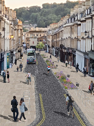
Artist's impression of 'Top of Town'
Working in collaboration with the Milsom Quarter Masterplan, this project seeks to reduce and remove car access and enable public realm improvements and pedestrian/visitor accessibility along:
- Milsom Street
- Broad Street
- Walcot Street
- Trim Street
It also seeks to manage car parking and remove through traffic, possibly making cross city centre movements unachievable. The study is considering a long-term option, which is discussed in the Future Projects section of this report.
Status: Developing
Delivery timescales: Medium- to long-term
Other themes supported:
Better public transport options
Providing for travel on bike and foot
Potential scale of carbon impact: High
Milsom Quarter Masterplan
The ambition is to transform and reimagine the future of Milsom Quarter, creating a more vibrant and diverse part of the city with a greater mix of uses, activity and residential development to redefine and increase the sense of community and local purpose. We want to invest in a better commercial offer, and increase footfall and usage of the Milsom Quarter area by both local people and visitors, promoting the area as an opportunity for regional-scale investment.
Transport will form an important element of this transformation including the provision of safe walking and cycling routes to, through and within the Milsom Quarter whilst also facilitating bus accessibility and reducing the impact of cars and service vehicles. Milsom Street as well as the roads adjacent to it are subject to an additional ‘Top of Town’ Transport and Movement Study, which will further enhance the travelling experience for both residents and visitors to the area.
Status: Developing
Delivery timescales: Medium- to long-term
Other themes supported:
Providing for travel on bike and foot
Potential scale of carbon impact: Medium
Traffic cells
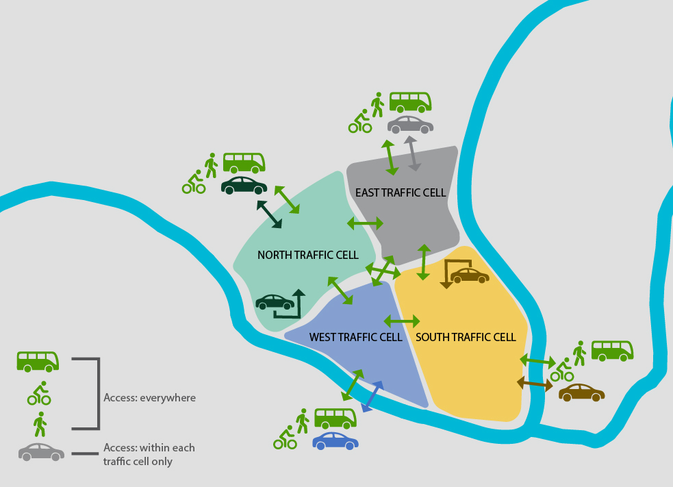
Map showing examples of traffic cells in Bath
This is a long-term option to achieve the combined aspirations of the Bath ‘Top of Town’ Transport and Movement Study, the Milsom Quarter Masterplan, the City Centre Security and Liveable Neighbourhoods projects. Traffic cells change the way in which the city centre is accessed by dividing it into a number of segments. Vehicular access to each segment is limited to one or two locations on the outer boundary and vehicles are prevented from travelling across the inner boundaries between segments. Movement between the segments is unrestricted and enhanced for public transport, pedestrians and cyclists.
In Bath, this would involve the creation of four city-centre traffic cells which would remove all through-traffic from the ‘Top of Town’ and the wider city centre – unlocking significant public realm benefits in the historic core of Bath, a World Heritage Site. This initiative would include the areas across the entire Top of Town area:
- Grand Parade and High Street
- Dorchester Street
- James Street West
- Green Park Road
As the project develops, access for people with mobility difficulties will be fully considered.
The creation of the traffic cells could be seen as one of the final steps in transforming the city centre, with the City Centre Security project delivering the first step followed by the Bath ‘Top of Town’ Transport and Movement Study and Milsom Quarter Masterplan.
The combination of all these projects will enable a wider reallocation of road space with significant improvements to active travel, public transport facilities and the public realm.
Status: Future
Delivery timescales: Long-term
Other themes supported:
Better public transport options
Providing for travel on bike and foot
Potential scale of carbon impact: High
Liveable Neighbourhoods - Next Generation
We are already developing the Liveable Neighbourhoods concept in B&NES with the first phase of locations identified (see Our Current Projects). The next step would provide an opportunity to increase the number and size of the initial Liveable Neighbourhood areas as a next step. As part of this, we will identify and assess key arterial routes to develop a circulation plan similar to the one developed in Ghent, which is discussed in the case study below. These would then become the key routes for traffic cells that control access for general traffic to an area through specific or single points.
On the arterial traffic routes, we will seek to provide priority for bikes, and where possible seek to separate bikes, pedestrians and public transport from general traffic. Cross and radial traffic cell/liveable neighbourhood connectivity would be retained and enhanced for active and sustainable transport options.
Case Study: The Ghent Circulation Plan
Ghent in Belgium is an historic, vibrant and growing city. It has 260,000 residents and contains UNESCO World Heritage Sites. In 2017 the city launched the Ghent Circulation Plan, which prevents motor traffic from crossing the city centre. The small Belgian city showed it was possible to make significant changes overnight.
The Plan has led to a 12% decrease in car traffic during the rush hour, a 25% increase in bicycle users, 8% increase in public transport, with retail sales increasing by between 2% and 10%.
The total cost of the scheme was a relatively modest £3.4 million. The Plan was implemented as a whole “overnight”, which was seen as the easiest way to deliver the proposed changes.
Status: Future
Delivery timescales: Long-term
Other themes supported:
Providing for travel on bike and foot
Potential scale of carbon impact: Medium
Bath Clean Air Zone and Air Quality Management Area reviews
Through continuous monitoring of the current Clean Air Zone (CAZ), additional local measures could be introduced if necessary, to address breaches of legal levels of nitrogen dioxide in the following areas:
- Bath City Centre
- Keynsham
- Saltford
- Temple Cloud
- Farrington Gurney
Once we achieve compliance, the CAZ will need to be retained for a period afterwards to demonstrate it is a long term improvement. The CAZ is therefore being kept under continual review both by ourselves and the Department for Environment, Food and Rural Affairs (DEFRA).
Status: Future
Delivery timescales: Short- to medium-term
Other themes supported:
Creating improved places to live and work
Potential scale of carbon impact: Medium
Demand management
Travel demand management is a multi-faceted approach to reducing vehicular traffic and promoting sustainable modes of travel. There are a range of measures that could be considered for demand management based on the three pillars of sustainable travel: capacity creation, network management and behavioural change in alignment with our net-zero journey. We will seek to apply the DfT’s Travel Demand Management Toolkit, published in March 2021, which sets out a five-step process in the identification and implementation of possible measures.
The five-step process is:
- collect and analyse data
- identify possible solutions
- implement solutions
- marketing, communications and engagement
- monitor, evaluate and adapt
Demand management measures could include, but are not limited to:
- car sharing
- public transport discounts or ticketing incentives
- workplace parking levy
- congestion charging or road user charging
- traffic signal improvements
- enhanced visual management system (VMS) to car parks (short and long stay)
- staggered start times for business and places of education
- review business travel planning that could reduce vehicle journeys
- establishment of Local Hub Networks to encourage shorter journeys that could be undertaken by sustainable modes
Status: Future
Delivery timescales: Long-term
Other themes supported:
Better public transport options
Providing for travel on bike and foot
Connecting Bath to rural communities and market towns
Potential scale of carbon impact: High
Coach strategy
The development of a coach strategy is a commitment within the JLTP4. Given its historic nature and heritage assets, Bath is a prime destination for tourists, and tourism is a key element of our local economy. However, the volume of visitors travelling into Bath impacts on our transport system and the environment in the city centre.
The high volume of coaches can have a detrimental effect, with impacts on noise, air quality and visual impact, as well as unofficial parking. There is therefore a need to improve the management of coaches, which includes embracing new technologies for better enforcement and monitoring, better pedestrian routes and wayfinding between coach drop-off/pick-up areas and the city centre, and more efficient movement and parking. It is also important that Bath continues to be attractive for coach tourism and leisure to sustain the tourist economy, so we want to provide facilities to enable visitors arriving by coach to do so in a safe, convenient and comfortable manner.
Status: Future
Delivery timescales: Medium-term
Other themes supported:
Better public transport options
Potential scale of carbon impact: Low
Rail freight distribution site
The provision of a rail freight distribution site has been enshrined within the B&NES Placemaking Plan as part of Policy ST4. The policy has safeguarded land at Westmoreland Station Road as a rail freight facility and interchange. The railhead at Westmoreland Station Road has been used to transfer and transport compacted waste and may have the potential to be used in the transportation of aggregates in the future.
Status: Future
Delivery timescales: Long-term
Other themes supported:
Potential scale of carbon impact: Medium
Road freight package
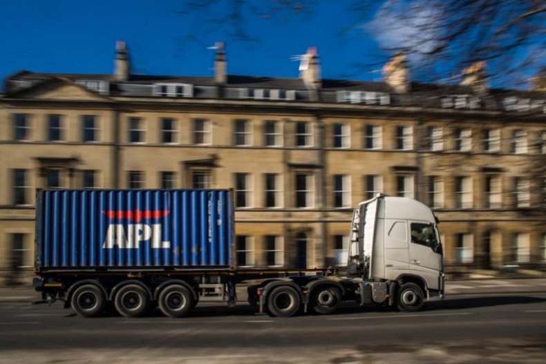
Building on the successful delivery of the freight consolidation, e-cargo bike, and last-mile delivery Support project discussed in current projects above, we would seek to further restrict HGV movements through freight consolidation and access restrictions whilst promoting and growing the e-cargo bike offer. This could include the provision of dedicated corridors as well as the potential for freight to be transported on buses. It would also align with and support our ambition for a rail freight distribution centre as well as the Freight Strategy that the Western Gateway are developing for the wider region.
Status: Future
Delivery timescales: Medium-term
Other themes supported:
Potential scale of carbon impact: Medium
What does this mean for me?
Reallocating road space to people on foot benefits the trade of adjacent shops.
An increasingly pedestrian-focused city centre will create a vibrant and liveable location for a variety of activities, from working, to shopping, to living, while maintaining bus, taxi, bike, scooter, and disabled access to ensure that Bath is a destination for all.
Travel into the city along key corridors by sustainable modes will be enhanced, making it much easier to enjoy all parts of the city regardless of where you live.
Car clubs will provide non-car owners with access to a vehicle for when needed, at a reasonable price.
Existing car owners may choose to switch to using a car club, removing parked cars from the road which on average are parked 96% of the time.
Both on-street and off-street electric vehicle charging will support the transition towards electric vehicles, making it more convenient than the current trip to a petrol station.
The provision of off-street electric vehicle charging locations at community and transport hubs could facilitate more local economic activity with people potentially going to local shops and cafes while vehicles charge.
The significant economic benefits brought by tourists arriving on coach will still be enjoyed, but coaches will not intrude upon the city’s environment, or into the lives of its residents.
A rail freight facility would have the potential to remove a significant number of heavy goods vehicles from road corridors into the city, providing space for other modes including public transport, walking, and cycling.
Consolidation centres will stop heavy goods vehicles entering the city when the delivery could be undertaken by smaller light goods vehicles or e-cargo bikes instead, improving road conditions, air quality, and reducing the cost of deliveries.
E-cargo bikes and other zero-emission last-mile delivery services will provide easy access to the city centre and other hard-to-reach areas.
Through working with businesses, better timed and managed city centre deliveries will ensure that freight movements do not exacerbate congestion at busy times and will make for more efficient deliveries to the benefit of hauliers and delivery recipients