This scheme aims to rebalance the facilities in Beckford Road, in particular making it safer and easier for active forms of travel, such as cycling and walking.
Expand the sections below to find out more about what our plans may mean for various groups.
New cycle lane
We plan to create a cycle lane on the north (uphill) side of Beckford Road.
The cycle lane will be separated from motor traffic in two ways:
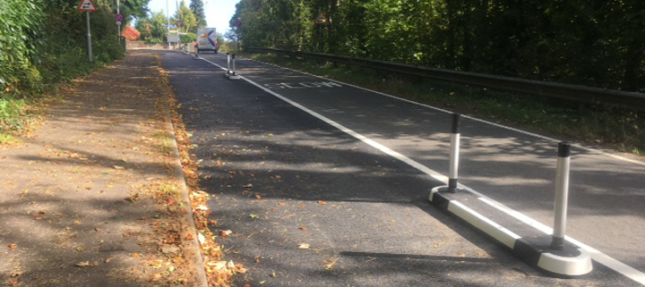
- Using bollards and splitter islands (‘light segregation’) to separate cyclists from other vehicles
- Providing a ‘bus stop boarder’ so that cyclists can remain within the cycle lane, even if there is a stationary bus
In 2020, we consulted on reducing speed limits in a number of roads in Bath, and will be introducing a 20mph limit in Beckford Road during 2021/22.
The current proposals do not involve a cycle lane on the south (downhill) side of the road. To do this, we would have to remove one of the three lanes for general traffic. This could require extensive alterations to the signalised junction with Bathwick Street and Sydney Place. The impact and cost implications of this were beyond the timescales and budget available for these schemes. We have therefore given priority to creating a better uphill cycle route, which provides the most benefit to cyclists and also enables us to make improvements for pedestrians.
Changes since the previous consultation
New measures to separate cycle lanes from traffic
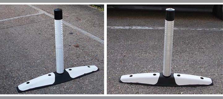
We've changed our proposal for ‘light segregation’ measures, to separate the cycle lanes from motor traffic. We had planned to use splitter islands at the start of the cycle lane, followed by bollards called ‘wands’ at regular intervals, to prevent traffic from entering the cycle lanes.
Following feedback from the emergency services, we still intend to use the islands at the start of the cycle lane, but the wand measures are now spaced every 15 metres with ‘mini orca’ measures in between.
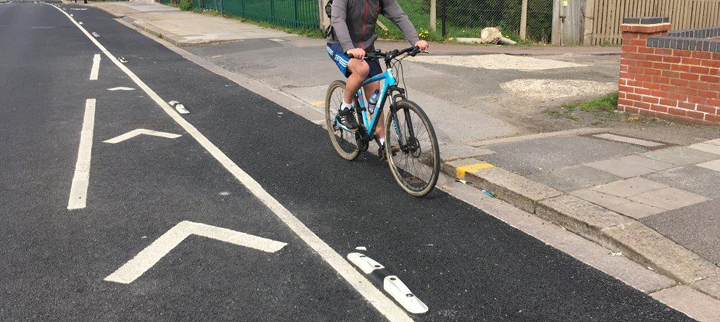
An example of a mini orca cycle lane separator (Copyright: Rediweld Traffic)
An example of a wand cycle lane separator (Copyright: Rediweld Traffic)
An example of a splitter island cycle lane separator (Copyright: Rediweld Traffic)
Making the cycle lanes easier to see, where they pass side road entrances
At the point where the cycle lanes pass in front of side-road junctions, such as Forester Road, it is not possible to include the physical measures to separate cyclists from motor traffic. We are therefore proposing to provide a red surfacing where cycle lanes pass side-road entrances, to make them easier for drivers to see.
View the detailed plans for cyclists in our previous consultation.
Continuous footways
A continuous footway is a relatively new method of making crossing side-roads safer for pedestrians. They signal that people priority have over vehicles, where side-roads join main roads. The level of the road surface at the junction is raised to the same height as the pavement, with gentle ramps for drivers. The road surface also changes, to give the appearance that the pavement continues across the entrance of the side-road. There are also ‘give way’ lines to show drivers that they have to give priority to people crossing.
The government recently announced forthcoming changes to the Highway Code which will make it clearer that drivers have to give way to pedestrians who are crossing a side-road junction.
We will provide continuous footways at each of the side-road junctions. At Beckford Gardens, the existing refuge island would need to be removed to provide the continuous footway. This new measure will be clearer to drivers that they should stop and give way to pedestrians wishing to cross.
View a similar scheme on Google Streetview
View the detailed plans for pedestrians in our previous consultation.
20mph speed limit
We will implement a 20mph speed limit, following a separate consultation last year. This will help make our roads safer places for people who are walking or cycling.
Parking and loading
It will be necessary to remove on-street parking along Beckford Road where the cycle lane is proposed. This would mean removing 20 spaces between Forester Road and Beckford Gardens and a time-limited parking bay near the railway bridge which can accommodate 8 cars.
If the scheme goes ahead, we propose to provide the following alternative parking:
- Removing double yellow lines in Forester Road to free up parking for 4 cars with Zone 10 permits
- Providing a time-limited parking bay to accommodate 5 cars in Warminster Road
Changes since the previous consultation
In North Road, we had previously proposed to provide a new time-limited parking bay for 3 cars, in place of a section of double yellow lines. Feedback from the consultation expressed concern that vehicles parked here could cause congestion at the start and end of the school day, when traffic in North Road is at its busiest. In view of this, we are no longer proposing any new parking bays in North Road.
Relocated bus stop
We would move the bus stop on the northwest side of the road a short distance up the hill. Its current location can cause difficulties for drivers and riders coming out of Forester Road, when there is a bus at the stop. Moving the stop slightly further away will improve visibility at the junction.
View illustrated explanations of parking and loading restrictions and road markings
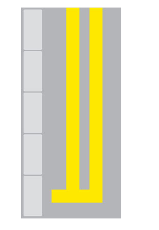
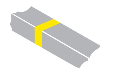
Double yellow lines prohibit parking at all times, referred to as ‘waiting’ in Traffic Regulation Orders. Stopping on or next to double yellow lines for the purposes of loading, unloading, picking someone up or dropping them off is permitted at all times, unless there is an additional loading restriction in force.
An example of double yellow line road markings
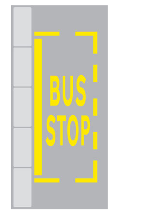
At bus stops where there is the yellow bus stop ‘cage’ marking on the road and a thick yellow line next to the kerb, stopping is not permitted except for buses and taxis. This means all other vehicles are not permitted to stop there at any time, not even for loading or picking up and dropping off passengers. This restriction already applies to bus stops in Bath.
An example of bus stop road markings
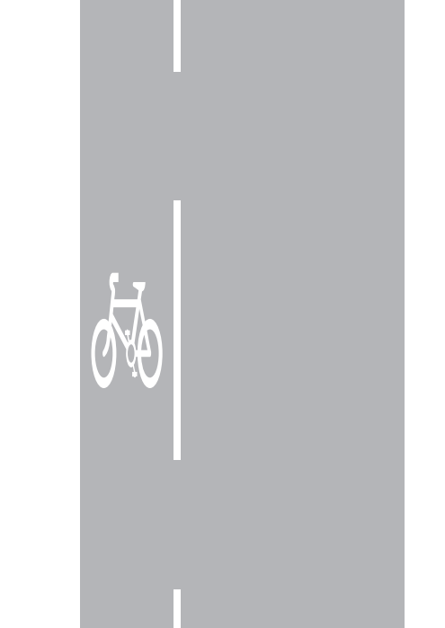
A cycle lane with a continuous white line is known as a mandatory cycle lane. Motor vehicles are not permitted to enter a mandatory cycle lane, except in an emergency. This means stopping in a cycle lane for loading or dropping off and picking up passengers is not permitted, regardless of whether there is a yellow line restriction within the cycle lane. We would provide an additional exemption to allow window or gutter cleaning vehicles when using a hose attachment to enter the cycle lane because of the need for properties to be serviced and since the occasions when they will need to do this will be infrequent.
An example of cycle lane road markings
Where cycle lanes pass a junction or access road, it changes to a dashed white line, which means motor vehicles may cross it for the purpose of entering or exiting that access or side road. We would provide a red colour within the cycle lane in our scheme to make the presence of the cycle lane clearer to drivers. The government recently announced forthcoming changes to the Highway Code which will state that drivers turning across a cycle lane to enter a side-road must give way to cyclists who are travelling straight ahead.
An example of cycle lane road markings at a junction or access road
Stopping next to the cycle lane for the purposes of loading, picking up and dropping off passengers is permitted.
Reducing the impact of motor traffic
The scheme should change the character of Beckford Road. We aim to restrict where motor traffic can go and encourage more people to travel by bike and on foot, resulting in less congestion and better air quality in your neighbourhood.
Improvements for pedestrians should also mean better road safety, improved accessibility for buggies and wheelchair users, and reduced traffic noise.
Road space for parking
It will be necessary to remove on-street parking along Beckford Road where the cycle lane is proposed. This would mean removing 20 spaces between Forester Road and Beckford Gardens and a time-limited parking bay near the railway bridge which can accommodate 8 cars.
If the scheme goes ahead, we propose to provide the following alternative parking:
- Removing double yellow lines in Forester Road to free up parking for 4 cars with Zone 10 permits
- Providing a time-limited parking bay to accommodate 5 cars in Warminster Road
Changes since the previous consultation
In North Road, we had previously proposed to provide a new time-limited parking bay for 3 cars, in place of a section of double yellow lines. Feedback from the consultation expressed concern that vehicles parked here could cause congestion at the start and end of the school day, when traffic in North Road is at its busiest.
In view of this, we are no longer proposing any new parking bays in North Road.
Relocated bus stop
We would move the bus stop on the northwest side of the road a short distance up the hill. Its current location can cause difficulties for drivers and riders who are coming out of Forester Road, when there is a bus at the stop. Moving the stop slightly further away will improve visibility at the junction.
View illustrated explanations of parking and loading restrictions and road markings
Double yellow lines prohibit parking at all times, referred to as ‘waiting’ in Traffic Regulation Orders. Stopping on or next to double yellow lines for the purposes of loading, unloading, picking someone up or dropping them off is permitted at all times, unless there is an additional loading restriction in force.
An example of double yellow line road markings
Loading restrictions are shown by a yellow ‘tick’ marking on the kerb and accompanying signs on the roadside. A single yellow tick means loading is prohibited at certain times of the day, and drivers should refer to the signs for those times. A double yellow tick marking means loading is prohibited at all times (our proposals do not include any ban of loading at all times). When a loading ban is in force, vehicles are not allowed to stop to load or unload. However, stopping to enable a passenger to get into or out of a vehicle is still permitted.
An example of loading restrictions road markings
At bus stops where there is the yellow bus stop ‘cage’ marking on the road and a thick yellow line next to the kerb, stopping is not permitted except for buses and taxis. This means all other vehicles are not permitted to stop there at any time, not even for loading or picking up and dropping off passengers. This restriction already applies to bus stops in Bath.
An example of bus stop road markings
A cycle lane with a continuous white line is known as a mandatory cycle lane. Motor vehicles are not permitted to enter a mandatory cycle lane, except in an emergency. This means stopping in a cycle lane for loading or dropping off and picking up passengers is not permitted, regardless of whether there is a yellow line restriction within the cycle lane. We would provide an additional exemption to allow window or gutter cleaning vehicles when using a hose attachment to enter the cycle lane because of the need for properties to be serviced and since the occasions when they will need to do this will be infrequent.
An example of cycle lane road markings
Where cycle lanes pass a junction or access road, it changes to a dashed white line, which means motor vehicles may cross it for the purpose of entering or exiting that access or side road. We would provide a red colour within the cycle lane in our scheme to make the presence of the cycle lane clearer to drivers. The government recently announced forthcoming changes to the Highway Code which will state that drivers turning across a cycle lane to enter a side-road must give way to cyclists who are travelling straight ahead.
An example of cycle lane road markings at a junction or access road
Stopping next to the cycle lane for the purposes of loading, picking up and dropping off passengers is permitted (although loading is not permitted when a signed loading restriction is in force).
View the detailed plans for residents and businesses in our previous consultation.
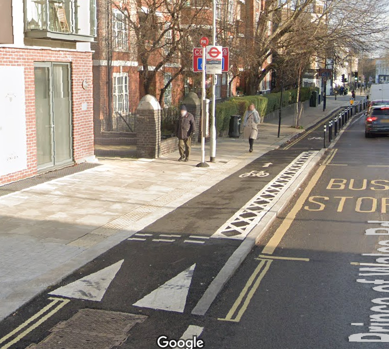
Our proposals will mean that the existing bus stop on the north (uphill) side of the road is redesigned to include a bus stop ‘boarder’. The new cycle lane will run next to the kerb. This means that you will need to cross the cycle lane when you get onto or off a bus, but you will have priority over cyclists.
To ensure that cyclists slow down and look out for bus users, there will be textured paving and a ramp when approaching a bus stop.
The cycle lane surface will rise to match the pavement at bus stops, so that access to buses doesn’t cause additional problems for wheelchair users or buggies.
Changes since the last consultation
Following feedback, we have enhanced this bus stop design to include signs and road markings to make it clearer to cyclists that they must give way to pedestrians.
The image below shows a similar design, although our proposal also includes a red coloured cycle lane, where it passes at the same level as the pavement.
An example of a bus stop boarder (Copyright: Google)
Relocated bus stop
We would move the bus stop on the northwest side of the road a short distance up the hill. Its current location can cause difficulties for drivers and riders coming out of Forester Road when there is a bus at the stop. Moving the stop slightly further away will improve visibility at the junction.
View the detailed plans for bus users in our previous consultation.

