Use this page to have your say on the new through-traffic restriction trial on Sydney Road at its junction with New Sydney Place.
The trial was installed in April under an experimental traffic regulation order (ETRO) for a minimum of six months, during which time we will monitor any traffic and air quality impacts.
We recommend that you respond to this consultation after you have experienced the trial for several weeks. The consultation closes on 3 October 2024.
We will thoroughly consider all the consultation feedback alongside monitoring data and our wider council policy before deciding whether to remove the scheme or make it permanent.
Why are we consulting
We want your feedback on the through-traffic restriction trial, how it has improved or impacted your life and whether or not you wish for the temporary through-traffic restriction to be made a permanent fixture.
Purpose of the scheme
The trial has been introduced under our Liveable Neighbourhood (LN) programme. In line with the broader objectives of the LN programme, the through-traffic restriction aims to:
- prevent motorists from using this residential street as a short cut (to avoid the Bathwick St/Beckford Road A36 junction)
- improve the safety of the Sydney Rd and North Rd junctions with Warminster Road (A36)
- create a safer, quieter, and healthier street for those walking, cycling, or wheeling through the area
- encourage more people in the area to walk or cycle shorter journeys and reduce the numbers of short journeys made by car
We believe that it's important to provide safe and pleasant routes for walking and cycling, because not everyone drives a vehicle (or wants to be dependent on one). It's also widely understood that getting out and about in our communities is good for our health and wellbeing.
Find out more about the Liveable Neighbourhood Programme.
Find out more about the New Sydney Place and New Sydney Road LN area development.
Scheme details
The through-traffic restriction comprises a set of six bollards placed across Sydney Road at its junction with New Sydney Place.
The scheme does not restrict vehicle access to homes, but it may require drivers to take alternative routes from either side of the restriction. Cyclists, pedestrians, and people with mobility aids will be able to pass through the filter. The two central bollards can be removed for access by the emergency services.
Existing parking arrangements on the street have not changed, and no parking has been removed.
Additionally, we have removed the dedicated filter lane into Sydney Road from Warminster Road (A36, towards Bath) and made improvements to junctions. Advanced signage is provided.
Please look at the annotated maps on this web page and expand the corresponding sections below for more detailed information using the numerical key.
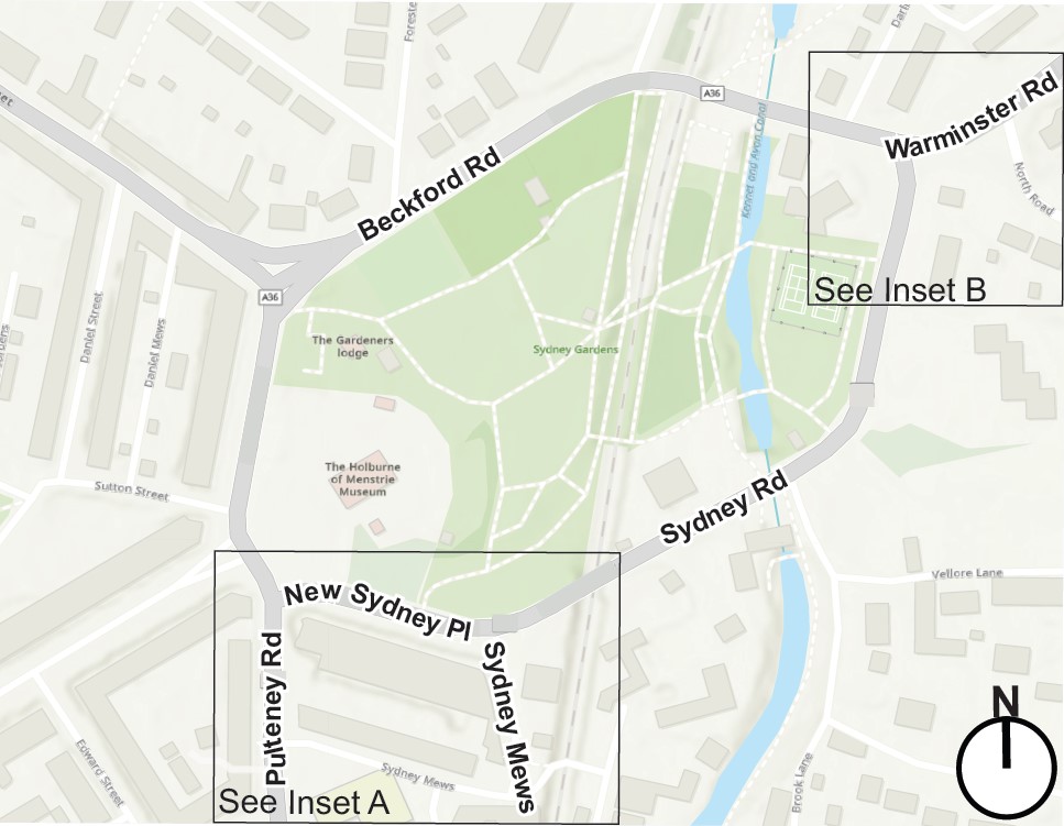
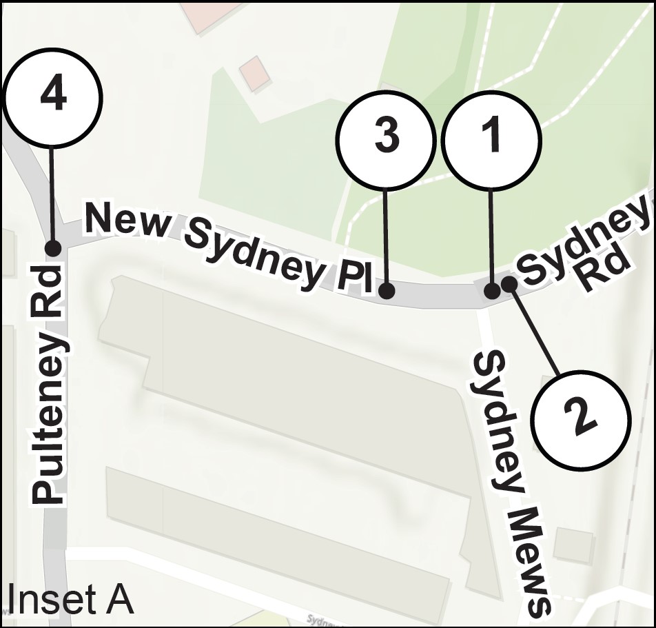
- Six bollards lie across the road at the junction of Sydney Road with New Sydney Place.
- Vehicle access is retained for all homes and businesses on Sydney Road via the junction with Warminster Road (A36), with enough space for vehicles to turn and no loss of parking in front of the bollards.
- Vehicle access is retained for all homes and businesses on New Sydney Place via Darlington St/Pulteney Road (A36) with enough space for vehicles to turn and no loss of parking.
- Advanced warning signs are installed at the junction with New Sydney Place to inform motorists of the through-traffic restriction.
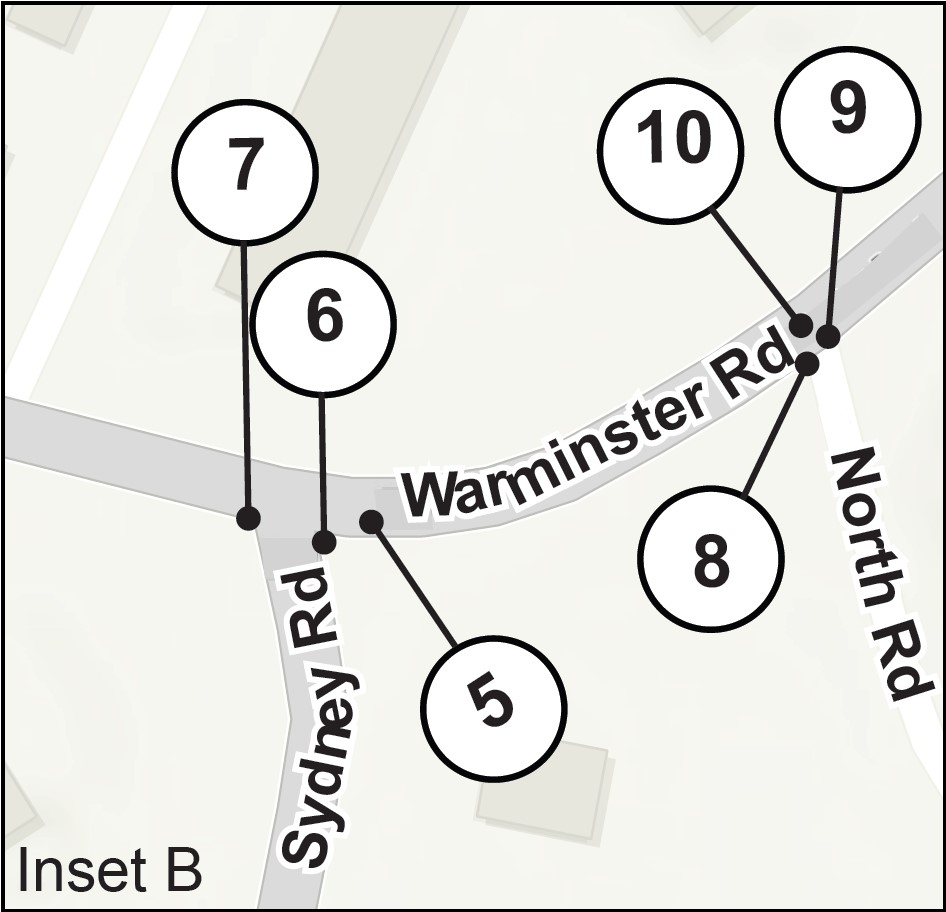
- We have removed the dedicated filter lane into Sydney Road from Warminster Road/A36 (towards Bath).
- We have widened the footpath on the eastern side of Sydney Road at its junction with Warminster Road to narrow the junction.
- We have installed signage to alert motorists of the no-through-road.
- We have widened the footpath on the eastern side of North Road at its junction with Warminster Road and extend the island on North Road to narrow the junction.
- We have improved the informal crossing on North Road at the junction with Warminster Road, by installing dropped kerbs and tactile pavement.
- Advanced warning signs inform motorists of the no-through-road to the A36 via Sydney Road.
Previous public engagement
Please expand the sections below to read more about previous consultations on Liveable Neighbourhoods and in the New Sydney Place and Sydney Road area:
During a public consultation in Autumn 2020 on Liveable Neighbourhoods in B&NES, we received the following results from 1,575 respondents (including residents and visitors to the area):
- 85% said they agreed with the principle of reducing the dominance of vehicles in residential areas
- 84% said they agreed that to establish LNs, it may be necessary to restrict through traffic on certain streets
- 78% agreed that certain trade-offs are required to achieve those aims
During public engagement on the Sydney Road LN area in November/December 2021, the most common issues experienced by residents in the area were ‘through traffic’ and ‘speeding traffic’. We also noted significant support among respondents (75%) in favour of a measure to tackle through traffic.
During our co-design workshops in Summer 2022, residents suggested a modal filter (through-traffic restriction) should be considered to tackle the issue.
Have your say
You can respond to this consultation by completing our online form. We recommend that you experience the trial for several weeks after installation before you submit a response.
Responding to this consultation should take no more than 5 to 10 minutes.
You will need to provide your name, address, and postcode to complete the survey, this helps us analyse your feedback. You are welcome to respond more than once during the consultation period if your opinion of the trial changes, or any issues arise.
Once you have answered the mandatory questions, at the end of the survey there is space for you to add your own comments and explain your personal position in more detail.
Accessible formats
If you are unable to submit your feedback using the online questionnaire, please request a printed copy or a copy in an alternative format by emailing LNs@bathnes.gov.uk or calling.
If you are unable to complete a questionnaire in any format, you may send a letter or email. Please include your full name, address, postcode (and email if available), and clearly state in the title that it is a letter of objection or support for the Sydney Road trial and outline the reasons for your view in the body of the letter or email. You can send this to LNs@bathnes.gov.uk or to The Liveable Neighbourhoods Team, Sydney Road ETRO Trial, Lewis House, Manvers Street, Bath BA1 1JG.
Monitoring
In October 2023, we collected baseline air quality and traffic data that will allow us to measure the impact of the restriction on the trial street and surrounding roads. We collected the data over a 7-day period outside of school holidays.
View the raw baseline data (2023/2024)
We will conduct in-trial monitoring during the first four to five months of the trial, to understand how traffic flows and air quality has changed.
We will compare and interpret each set of data and publish this in a report to support the final decision.
A36 Warminster Road closure
Diversions will be in place for the duration of the closure. This will impact normal traffic flows on Warminster Road in the Bathwick area, so we will not conduct any traffic monitoring during this time.
We will complete our traffic and air quality monitoring for this scheme before these works start, and outside of school holidays. The consultation will remain open until 3 October 2024 as planned.
View the press release on this essential repair work.
Attend a consultation event
An event will be held during the six-month consultation once residents have had a chance to experience the change in road lay out for several weeks. When event details are available, we will update this page and inform residents.
You can also subscribe to our newsletter and follow the council on social media to be kept informed of news and events on the LN programme (and this trial).
What happens next
Once the consultation ends in October 2024, we will consider all feedback before we decide whether to permanently adopt the scheme or remove it. We will take the following into account:
- Comments received during the trial
- Monitoring data, including traffic and air quality data
- Council policies including our Corporate Strategy, and wider sustainable transport and Climate Emergency policies, such as our Journey to Net Zero ambitions
A decision on whether to make the ETRO permanent must be made within 18 months of the start of the trial.
The consultation output reports, monitoring data and decision notice, will be published on this website. We will inform residents of the outcome by letter.
View ETRO documents
ETRO documentation consists of 3 documents:
- A summary of the proposed Order
- A report which shows the decisions behind the Order
- A notice and mapping, showing where the Order will apply, and the legal wording (the notice will include blanks for dates and signatories, which will be completed if the Order is approved and implemented)
To find out more about ETROs you can expand the sections below
Traffic Regulation Orders (TROs) and Experimental Traffic Regulation Orders (ETROs) are the legal documents that restrict or prohibit use of the highway network. They help manage the highway network for all road users, including pedestrians, and they aim to improve road safety and access to facilities.
We can use permanent or temporary TROs and ETROs to manage on-street parking, to ensure that this is fair to all road users, and the way that we control and enforce regulations is transparent.
For permanent changes to traffic regulation, we generally only introduce a TRO or ETRO following a period of research, consultation and discussion of proposals, leading to a decision. We invite members of the public, experts, and councillors to contribute to that discussion, and our Director of Place Management makes the final decision.
The TRO is issued when we are preparing to implement regulations. We are legally obliged to advertise all TROs and give the public an opportunity to state their support or objection to them. These comments will be publicly available after the TRO consultation.
The final decision to implement new regulations will be made after the TRO consultation. Once a TRO is sealed, or becomes official council policy, we publish it permanently on our website. It then normally takes a short period for the new regulations to come into force.