About this page
How this part of the Local Plan Options Document works
These potential site pages contain the following sections:
Site background
- A broad description of the site, with map if appropriate
- An overview of development proposed or already in progress
- Relevant aspects of planning policy for this site
- The history and status of any planning applications for this site
Discussion questions
We'll ask one or more broad questions which may cover:
- the suitability of the site for development
- the policy issues we would need to consider
- asking for suggestions for alternative approaches, sites or ideas
Policy context note
- Where decisions about this site may affect how we approach other sites (or vice versa), we will add a note to explain
Explore this potential site
Select a section below to read more.
This is a potential site for development that we are unlikely to include in the Draft Local Plan. The site background presents the possible advantages of this site, balanced against the potential harm to the setting of Bath as a World Heritage Site (WHS), and the fact that the land currently has Green Belt status. We are including this potential site in the Local Plan Options Document with discussion questions that we would like your feedback on.
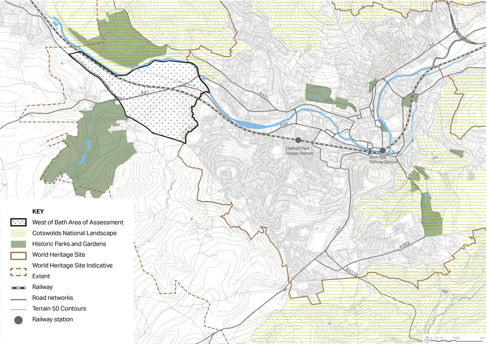
5.90 One of the locational options that has been considered to help address the development needs of Bath is land to the west of the city. This area could have potential to provide housing that is more affordable, new office or industrial buildings, or potentially to relocate the existing Newbridge Park and Ride, thereby freeing up the existing site for other forms of development. Map to be inserted showing West of Bath location.
5.91 The provision of development as outlined above could deliver public benefits and help to address objectively assessed needs, but this has to be weighed against the likely harm that development could cause to the World Heritage Site (WHS), particularly to the attribute of 'the green setting of the city in the hollow in the hills’ and impacts on the setting of the Cotswolds National Landscape. To evaluate this, the Council commissioned Land Use Consultants (LUC) to undertake a technical evidence assessment of the potential impacts of a range of development typologies in land to the west and south of Bath.
5.92 Whilst development to the West of Bath could have public benefits, the assessment by LUC shows that it is very likely to cause substantial harm to the World Heritage Site (WHS) and its setting and that this harm cannot be satisfactorily mitigated. It would also cause harm to the setting of the Cotswolds National Landscape.
Figure 14: Map showing West of Bath area for the LUC assessment into potential impacts of development
5.93 The NPPF makes it clear that substantial harm to the WHS should be ‘wholly exceptional’. In addition, the NPPF makes it clear that protection and enhancement of a heritage asset should be given great weight, and that as a WHS is the most significant asset, it should be given the greatest weight.
5.94 Growth of the city west of Bath and causing substantial harm is also likely to be of significant concern to UNESCO (particularly given the double inscription of the city) and this would also affect the other Spa Towns that are part of the Great Spa Towns WHS inscription which includes Bath.
5.95 The LUC assessment identified that harm caused to the Outstanding Universal Value of the WHS by the types of development tested is intrinsic and unavoidable because it will fundamentally alter the character and appearance of the areas as undeveloped agricultural land that provides the green setting for the city. This is considered to be an 'in-principle' issue that could not be overcome by design. No heritage benefits have been identified for any of the areas assessed.
5.96 Given the LUC assessment and the national policy context outlined above, it is considered at this stage that an allocation of land for development West of Bath is unlikely to be included in the Draft Local Plan. That said, it is included within this Local Plan Options document to test and ascertain whether substantial public benefits can be identified that would outweigh the substantial harm.
5.97 In addition to identifying substantial public benefit and whether this outweighs harm to the WHS and its setting, this location also lies within one of the most important areas of the Green Belt and the impact of development on the Green Belt would need to be carefully considered.
5.98 'Exceptional circumstances' would need to be demonstrated in order to justify removing the land from the Green Belt. Whilst such ‘exceptional circumstances’ are site specific this broadly means demonstrating that reasonable alternatives outside the Green Belt have been considered and rejected and that harm to the Green Belt is outweighed by the benefits of development.
Question 1
Do you consider that development in this area could provide substantial public benefits that might outweigh the substantial harm to the World Heritage Site? If so, what are these public benefits?
Question 2
Do you consider that these public benefits also demonstrate ‘exceptional circumstances’ that justify removal from the Green Belt? If so, please explain why, and what ‘reasonable alternatives’ you think we should consider.
Question 3
Are there specific sites or areas in the West of Bath location that you think we should consider?

