Strategy overview and key issues
Select a section below to read more.
7.68 Farrington Gurney sits on the junction of the A37 and A362 and has good access to the surrounding towns and cities. The village already supports a variety of facilities including a school, pub, restaurant and a community facility.
7.69 The Somer Valley Links project and Somer Valley Enterprise Zone will provide an off road cycle path into Midsomer Norton. The Somer Valley links project proposes a new mobility hub at Farrington Gurney.
7.70 Historically, the development of the village has moved away from St John’s Church, which is a listed building and now stands on its own in fields to the east of the village. The setting of the church will be an important consideration for any development proposals.
7.71 Farrington Gurney is surrounded by rolling, relatively flat countryside. The gentle escarpment to the south creates a boundary for any proposed development. The Nature Reserve at Hollow Marsh and the countryside are accessible via local Public Rights of Way.
7.72 The main constraint is that almost all of the land within the area of search is classified as Grade 1 in the Agricultural Land Classification, and land adjacent, to the south, is classified as Grade 3a. Grade 1 and 3a, are referred to as ‘best and most versatile’ land, where development should be avoided.
7.73 There are opportunities for a good size residential and landscape-led development. The new mobility hub along the A37 would help to achieve a net zero carbon development, and active travel is promoted throughout the development.
7.74 To improve walking, cycling and wheeling permeability throughout the village, the existing main roads need to be downgraded and vehicle speeds need to be reduced to provide improved pedestrian safety. Where possible, the existing pedestrian and cycle routes need to be improved and widened. A thorough archaeological investigation would be needed as part of the planning and development process.
7.75 There is an Air Quality Management Area within Farrington Gurney at the junction of the A37 and A362. The area is expected to become compliant at the end of 2023 and the latest monitoring data on air quality is awaited. However, an increase in development to the village may impact on air quality and any new development may need to contribute financial contributions to manage air quality.
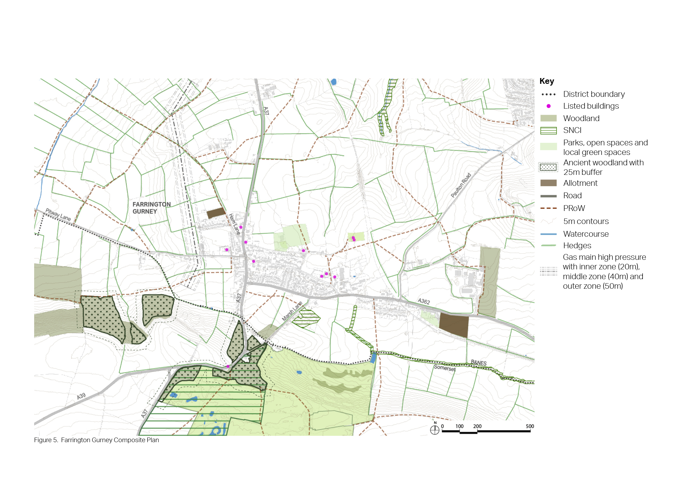
Figure 57: Context Plan - Farrington Gurney
- The setting of the existing Grade II listed church.
- The setting of the surrounding landscape.
- Impact of development on the existing highway network and access to public transport.
- Impact on the Farrington Gurney Air Quality Management Area (AQMA).
- Lack of housing that is affordable.
- Secondary-age pupils from any new development at Farrington Gurney will need to be transported to Norton Hill School in Midsomer Norton, at cost to the Council. These pupils will not be able to travel to school sustainably by active modes.
7.76 The following list sets out the key priorities and objectives for Farrington Gurney. Many of the priorities can be addressed by new development, and site options have been selected in response to the key issues, priorities and objectives. However, there are some priorities that won’t be addressed through new development but will be addressed through other policies in the Local Plan or initiatives undertaken by the Council or by other stakeholders.
- Around 500 homes could be provided, including housing that is affordable and meets local needs.
- The existing primary school is full, with no room to expand. Therefore, a new school would need to be provided which influences the scale or quantum of development required.
- Opportunities to improve local services and facilities.
- There is an opportunity to connect to the Somer Valley Links project which, along with the Somer Valley Enterprise Zone, will provide an off-road cycle link to Midsomer Norton. This will provide cycle connection to the network in Midsomer Norton.
- Landscape mitigation would be required to soften the impact of the development.
- Ensure any new development provides mitigation measures so as not to cause harm to the Air Quality Management Area.

