The Winifred’s Lane through-traffic restriction is being installed under an experimental traffic regulation order (ETRO) for a minimum of six months from summer 2024.
It is one of three linked restrictions in the Lower Lansdown ETRO trial, which is part our Liveable Neighbourhood programme. Its aim is to prevent motorists from using residential streets in the area as a short cut to and from the A46/M4.
During the trial, we will monitor its impacts and seek residents’ views in a six-month public consultation.
Overview of Winifred’s Lane trial
We will install two sets of bollards on Winifred’s Lane to prevent motorists from using the lane as a short cut. Pedestrians, cyclists and people with mobility aids will still be able to pass through. Additionally, we are introducing a no-right-turn into Sion Hill (East) from the northern end of Cavendish Road which does not apply to cyclists.
The section of Winifred’s Lane north of the restrictions will remain one way (northbound) and vehicle access to properties in Somerset Lane is via Lansdown Crescent. Emergency and service vehicles will be able to remove the bollards to gain access.
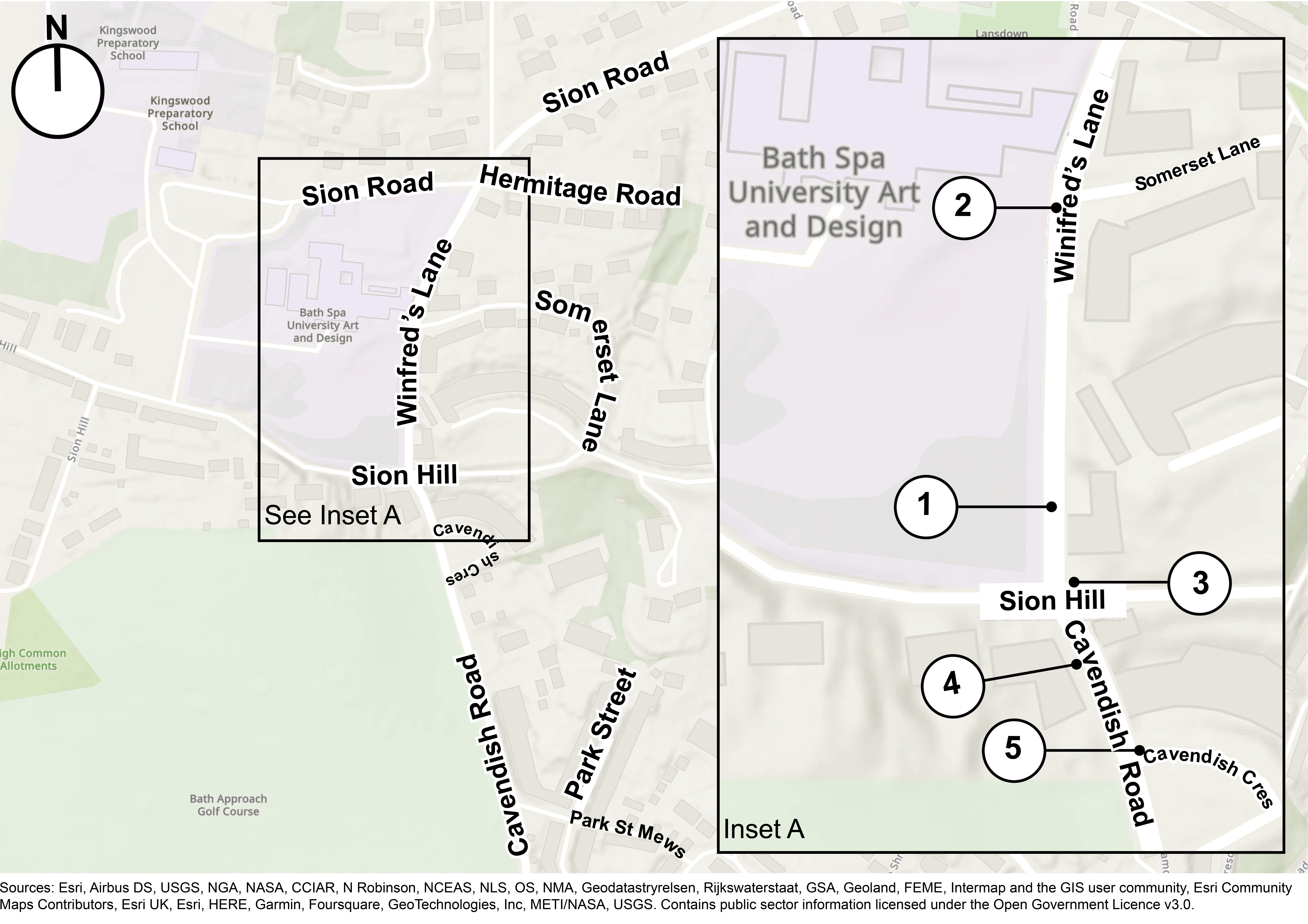
You can view more details using the map and annotations below.
Trial details
The following annotations correspond to the numbered map above:
- The first set of bollards will be placed just north of Holywell House (with access to and from the property maintained from the southern end of Winifred’s Lane).
- The second set of bollards will be placed just south of the junction with Somerset Lane.
- A ‘no through route for motorists except for access’ sign will be placed at the southern entrance of Winifred’s Lane.
- A ‘no right turn except cycles’ sign will be placed at the northern end of Cavendish Road to prevent all northbound traffic from turning right into Sion Hill (East)
- A ‘new road layout ahead’ sign on Cavendish Road will be placed at its junction with Cavendish Crescent to alert motorists of the changes to the road layout.
There will also be an additional signage placed further south on Cavendish Road at the junction with Julian Road to give motorists advance warning of the restrictions.
Find out more
For more detail on the trials, you can:
- Read an overview of the Lower Lansdown ETRO trial and have your say on all three linked trials
- Read more about the linked Gay Street trial
- Read more about the linked Catherine Street trial
You can contact us and talk to an advisor or request this information in an alternative format by emailing us at LNs@bathnes.gov.uk, or calling 01225 394025 and requesting a call back from a team member.

