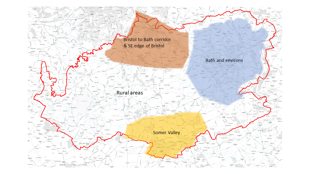
4.20 The District comprises a range of settlements, many of which are spatially and functionally related to each other. Considering these relationships is important, in looking at potential location options for development. In order to aid this process, and for the purposes of the Local Plan, Bath and North East Somerset has been divided into four main sub-areas, which are based around these connections and relationships. These sub-areas are illustrated on the map below. Some of the key spatial issues, opportunities and challenges in these sub-areas are briefly summarised below and are picked up in greater detail in the place-based chapters which follow.
Figure 11: Map showing locations of sub-areas within B&NES
4.21 The city of Bath is the main economic centre and largest settlement within Bath and North East Somerset. As such, it is the driver for much of the housing needed in Bath and North East Somerset and a focus for economic or employment space. The need for affordable housing is particularly acute in the city and as set out in chapter 2 this is the area of the District where housing is least affordable (with house price to earnings ratio in the city being higher than the rest of the district). The city also hosts two Universities, which also bring with them significant opportunities but also major impacts on the city’s housing stock and communities. Bath is also a double-inscribed World Heritage Site, home to over 5,000 Listed Buildings and tightly surrounded by the Green Belt and two thirds of it is wrapped around by the Cotswolds National Landscape. Bath and its environs support key components of the Bath & Bradford on Avon Bat Special Area of Conservation and the city retains significant wildlife interest particularly linked to the river corridor, hillsides and green fingers that characterise the city.
4.22 There is substantial pressure for development arising from housing and economic needs within the city, where land supply is limited and at a premium. Brownfield sites need to be re-developed where possible and at optimum densities in order to ensure such land is used efficiently, but in a way that respects the city’s sensitive context. Most of the significant brownfield sites have been redeveloped or are already committed for development and therefore, relatively few new brownfield sites available for development exist. Within this context the use of land within Bath needs to be carefully assessed and the needs which should be met must be prioritised. Opportunities for outward expansion of the city need to explored, but are also constrained by the quality of the environment and designations. The villages that lie within the hinterland of the city are also of special character and development opportunities are similarly limited. Options for development and which needs should be met and how are considered further in chapter 5.
4.23 Settlements within the transport and river corridor that connects Bath and Bristol, most notably Keynsham and Saltford, but also other villages closer to Bath are well to related to each other and accessible by public transport in terms of people’s journeys for employment and services and facilities. Crucially these settlements are also well linked to Bristol and Bath by public transport, both bus and train from Keynsham. The south eastern edge of Bristol, in particular the Hicks Gate/Brislington area, also lies not far to the north west of Keynsham. In addition to this area the village of Whitchurch lies close to the south eastern edge of the city. However, whilst it is relatively well connected into Bristol it is important to remember that Whitchurch village is a separate and distinct settlement and community.
4.24 The comparatively good public transport links are an important characteristic of this part of the district. However, it should be noted the main highway routes also suffer from congestion, especially at peak times. Therefore, investment is needed to further improve public transport services and active travel links to help address it.
4.25 Land on the south-east edge of Bristol and in the transport corridor linking Bath and Bristol lies within the Green Belt. Strategically this is an important part of the Green Belt in separating the two cities and the settlements that lie in between. The physical separation of not only Whitchurch village from Bristol, but also Keynsham from Bristol, and Keynsham and Saltford are also of great importance to the respective communities. In considering locations for development the need to retain, strengthen and enhance green infrastructure settlement gaps is crucial. As set out above land can only be released from the Green Belt for development through a Local Plan and only if justified by ‘exceptional circumstances’.
4.26 The River Avon corridor and supporting sub catchments are an important ecological network for the region, connecting Bath to Bristol and the communities between. The River Avon corridor also provides an important recreational route and sustainable movement corridor that can be enhanced for active travel for existing and new communities, and for boat dwellers living on the river. The River Chew, which is particularly relevant in having helped to shape Keynsham, is an important tributary of the River Avon.
4.27 The Somer Valley lies in the southern part of Bath and North East Somerset and adjoins the Somerset Council administrative area. For the purposes of the Local Plan the Somer Valley area focusses on the six closely connected settlements of Midsomer Norton, Radstock, Westfield, Peasedown, Paulton and Farrington Gurney. Other villages in the wider Somer Valley (such as High Littleton and Timsbury) are considered in the rural areas sub-area (Area 4, below). The Somer Valley has a rich mining and industrial heritage and a locally distinctive character, including a number of derelict coal batches with wildlife and cultural interest. It is important that the character of each settlement is respected in considering potential development locations.
4.28 There has been considerable recent housing growth in the area, delivered on a piecemeal basis, without the necessary supporting infrastructure keeping pace. In addition, out-commuting from the area to work is relatively high, and has increased in recent decades, due to economic restructuring within the area.
4.29 The Somer Valley is connected to Bath and Bristol by two major transport corridors (A367 and A37) and is relatively well served by public transport, although not as accessible to both cities as settlements in the Bath to Bristol corridor sub-area above.
4.30 Further significant investment is needed to improve public transport. Connectivity and safety improvements to the active travel network are also required. It is also important to deliver opportunities to improve local employment opportunities, including the Somer Valley Enterprise Zone, as well as delivering nature recovery and greater public access to greenspace.
4.31 A significant proportion of Bath and North East Somerset is rural in nature. The rural areas are made up of several areas of attractive and distinct landscape and settlement character (such as the Chew Valley), as well as the Mendip Hills and Cotswolds National Landscapes (formerly Areas of Outstanding Natural Beauty). Areas of strategic importance for nature recovery are being identified through the Local Nature Recovery Strategy and through the work of the Bristol Avon Catchment Partnership, and West of England Nature Partnership. The high quality of the environment and opportunities to access the countryside, as well as the strong sense of community identity in villages, are important to local communities. The connectivity by public transport from villages to larger urban centres is variable and is poor in some of the smaller villages, which also lack services and facilities that can be accessed by walking, cycling or wheeling.
4.32 As is the case across the district as a whole, there is a lack of affordable housing available in order to help meet local needs. Some housing development in villages can provide much needed affordable housing, as well as help to keep services and facilities viable and operating. However, it is important that any development in the rural areas meets the needs of those communities, respects locally distinctive character and is primarily focussed on those villages that are better connected through sustainable means of transport and have better access to key services and facilities.

